We are indebted to Tipton Historian Keith Hodgkins for a set of photos which he allowed us to use on this website. Keith is well known for his books on Tipton in collaboration with John Brimble, and the background to his story and interests in the area can be read HERE.
The following article sets the scene and was written by Keith in the magazine Black Country Connections. It gives a summary history of Sheepwash, and the changes that have taken place over the last 100 years, and even before that.
We have also traced more photos and documentation dealing with the site and set this out in chronological order. What this shows is that industrial landscapes blighted by former use CAN be transformed into something more positive, rather than the other way around.
The following picture is taken from the book Conurbation, a planning survey of Birmingham from 1948 and was taken as part of a train journey from Birmingham to Wolverhampton. We can see from this the flooded and fairly desolate area in front of the Pumphouse Brickworks and the engine house on the right of the picture. The stacks in the distance to the left are The Canal Brickworks.
Also recorded here is what appears to be the creation of The Denbigh Estate off The John’s Lane Farm. The fieldhouse building is to the right of the picture in John’s Lane.
The picture below shows a different angle of the site.
With the demise of brickmaking, the area became flooded with the cessation of pumping in the main pumphouse pit. West Bromwich Council bought the land in the 1960’s for use as a tip, which was largely unsanctioned building and industrial waste by contractors and the council itself.

Picture Chris Adams showing the flooded marlhole. The swan village gas holder is shown in the distance.
The following is taken from “A part of nature The greening of derelict industrial land- rehabilitation policies in Britain and Germany” Anglo-German Foundation.
“With reorganisation of local government in 1974, the newly formed WMCC became the waste disposal authority. Ownership of most of the site was transferred to the WMCC, which continued tipping operations until 1978. At that stage, the pumphouse pool was approximately 5 ha in area, with steep sided banks made entirely of domestic refuse. Below water level, the banks shelved away steeply to depths greater than 12 m. Water quality was poor as a result of leachate from the refuse. Waste deposits covered the site to a maximum depth of 20m, and comprised a mixture of degradable waste (domestic refuse, parks waste, slaughter house waste and building waste and contaminated waste chemicals, drums of toxic materials, oils and tars etc.). Of the estimated 1.5-2 million m³ of domestic waste, at least 500,000 m³ were biodegradable and capable of producing landfill gas.”
Site investigations in 1979 concluded that the site was unsuitable for residential or industrial development due to the dereliction and site contamination, whilst issues with the River Tame demanded flood prevention schemes being required. The “eyesore tip” and abandoned marlhole were going to be turned into something more useful.
A series of planning applications reveal the timescale of these improvement works. Unfortunately at present, the detail surrounding these is not available due to council restrictions on access.
DD/12405 | Reclamation of derelict land by the tipping of building waste & other materials. | Derelict land at Sheepwash Lane Tipton.
This application dates from September 1980. No decision notice is shown on the council website, which was rather odd. I put in a freedom of information request to SMBC in this regard asking for this, which can be read HERE.
The council stated “With regard to DD/12405 this application
was not determined as the proposed reclamation scheme was superseded by
the submission and subsequent grant of permission for ref: DD/15197.”
DD/15197 The reclamation of derelict land & the construction of balancing lakes including the infilling of the existing pool with inert materials to reduce water depth from 10 to 3 metres. The whole area is to be contoured and landscaped. Land off Sheepwash Lane Great Bridge, Tipton.
This was decided on 20th October 1982 with no conditions, (as confirmed by SMBC in the FOI request), which is again rather odd given the scope of the work involved. I would like to know what the “inert materials” actually were. This decision notice can be read HERE.
This application generated a waste management site licence. SL434 . I again put in an FOI to SMBC concerning this and the map of the area which they responded to.
“The plan shows the landfill boundary superimposed over present day mapping
(accurate to the date of issue) and hence should provide the requested
information.”
THIS MAP CAN BE VIEWED HERE.
The supplied waste management licence shows that it was issued on 30th September 1983 by The West Midlands County Council . This had two schedules. Schedule A had 38 conditions, with Schedule B which contained 3 general clarification points about waste types and procedures.
In schedule A there are mentions of plans, maps and a supplementary information document, (not supplied with the request and which the council claim not to hold which I am somewhat dubious about given that they made the application!).
A modification adding another condition 39 was made on 24th November 1983 which appears to relate to tipping and health and safety conditions in relation to the overhead powerlines. This would appear to have been an oversight on the part of the original licence and the difficult unmoveable objects that unfortunately had been erected many years before. Perhaps we can speculate that there may have been some near misses with works taking place, and the County Council wanted to make sure they were not liable for any serious accidents or deaths?
Before these applications we can get a good view of what Sheepwash was like from The Rose Lane area as witnessed in photographs taken by Keith on 24/3/1983. NB this was 6 months before the waste management licence was approved.
At this stage the River Tame ran differently, as shown in the diagram below. As part of the transformation this was redesigned for flood alleviation purposes, and you can see why.
Horses are grazed and a ramshackle stables appears on part of what is now the Rose Lane meadow. The River would now be to the left of where it is shown here. The pylon VT25 in what is now the Rose Lane Pylon pool would be rebuilt in a slightly different position in the 2010’s. .
I am reliably informed that this bridge across the river had holes in it and was in very poor condition. This bridge area I believe would equate to where the path from Elizabeth Road leads down to now.
The Pumphouse pool as it was, crossed by overhead powerlines and the angle tower VT24. Behind this are the Ocker Hill power station towers which were demolished in the 1980’s. Keith took a spectacular close up view of these before they were taken down which is shown in his living memory page. What we can see from this is that there are no islands and the area is very wild.
A striking image and contrast of two structures with the River Tame dividing them. On the left, the angle tower VT24 which is still there of course in what is now The John’s Lane meadow. On the right are the remains of the engine house from the pumphouse brickworks seen in the earlier picture. Another image of this structure can be seen HERE. A similar structure at Bumble Hole/Warrens Hall Nature Reserve was retained there. I remember this structure vaguely from this time, but it was demolished with the works. Perhaps this was an opportunity missed to preserve Sheepwash’s industrial past?
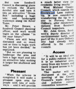
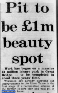
Newspaper articles promoting the new wildlife site began to emerge, as well as a council leaflet.

The Anne Close entrance with Newtown School on the left. Children from the school would plant trees around the border of the site.
Further works would commence with the creation of The Black Country Development Corporation who would use the site as a PR marketing tool for themselves with their frankly disastrous environmental blight activities across the area such as the Black Country Route. Sheepwash won a Royal Town planning Institute award for the creation of the urban park.
BCS0468 | Derelict land reclamation as part of the development of Sheepwash urban park. | Land rear of Triplex Foundry Sheepwash Lane Great Bridge.
The decision notice for this Northern part of the site can be viewed below.
The allotments area was also re-landscaped. It does appear that this phase of the project ran out of ideas or money as this area is certainly the most vacant area of the site.
With the pumphouse pool being transformed and shallowed, we can see that a haul road was used from what is now termed “the spit” area by bird watchers on the site. It appears that the central islands were created as part of this process. This picture must date from the early 1980’s.
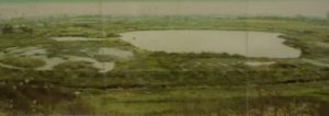
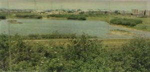
The following aerial panorama was taken as a picture and is held at Sandwell park Farm. I was gratefully sent this by the senior countryside ranger for use on this website. I have scanned the pictures individually to remake the one photo. Although small to see, if you click on each in turn, you can make out much more detail. Of course , the lack of tree cover is the most notable feature of the newly created layout, and it reminds me of a sculpted cake decorated with blue icing and island green “cherries”. I would estimate that this picture was taken in the mid to late 1980’s. The old brickworks engine house is gone, and in its place “the pumphouse” where the lake levels could be controlled. This in itself would be demolished with a fenced off open structure put in its place in the 2010’s by The Environment Agency.
The creation of the site on an old tip would not be without its problems due to methane gas being present, as this article from 1990 attests. There would be methane drains built around the perimeter of the site and monitoring of levels. On 21/4/1990 a further modification was made to the SL434 site licence as supplied by Sandwell Council in the FOI request, but this doesn’t make sense at present as conditions 33-36 concerning landfill gas do not appear to correlate with that licence? This is part of why such sites could not be built on to form houses, and it is a problem in other areas around this site.
Keith Hodgkins returned to the site and took this picture, which dates from 1991. This shows that the islands on both pools have taken shape and swans can be seen on the middle island on John’s Lane pool. Tree cover is still sparse but starting to grow. Thirty years later the site is unrecognisable from the industrial legacy that once had its footprint there as the only Local Nature Reserve in Tipton. .


